 NomadSwipe
Apps like Google My Maps: 6 alternatives for planning a trip
Apps like Google My Maps for planning a trip include Wanderlog, Mapstr, Stippl, Polarsteps and Roadtrippers. My Maps itself holds up to 10,000 places and 10 layers per map, according to Google. I built NomadSwipe, which adds swiping to the same idea.
My Maps is a good fit when you want to place every pin and draw every route yourself. People look for other apps when they want a ready-made trip structure, a phone-first way to build the map, or help finding places in the first place. The table below puts My Maps next to six alternatives, and the sections after it say what each one does and where My Maps is still the better tool.
Google My Maps alternatives at a glance
| App | Best for | Map and sharing | Where it runs | Catch |
|---|---|---|---|---|
| Google My Maps (baseline) | Hand-built custom maps with layers | Up to 10 layers; place search; directions; link sharing or public; export to KML/KMZ and CSV | Browser; view in the Google Maps mobile app | No itinerary or day feature in the help pages I read; 10,000 places per map |
| Wanderlog | An itinerary and a map in one view | Map view, route optimization, collaboration "in real time" | App and website | Pricing page returned a 404, so its price is not confirmed here |
| Mapstr | Saving addresses from many sources on one map | Imports from Google Maps and Foursquare; collaborative map; tags and comments | App and web version | Homepage is in French; it holds addresses you already found |
| Stippl | An AI-built day-by-day itinerary | Map every stop with distances and travel times; collaboration listed | App and website | More features to learn; price not checked this run |
| Polarsteps | Tracking and sharing a trip as you travel | Trip plotted on a map; you decide who sees it | App | A travel log first, a planner second |
| Roadtrippers | Road trips with stops along the route | Autopilot itinerary, or plan on your own | Website and app | Stops per trip are capped by plan, from 3 to 150 |
| NomadSwipe | Finding real places in a city by swiping | Saved places on a trip map, plus a list | Android; iPhone coming soon | Does not import a map and does not schedule days for you |
Google My Maps: what it does and what it does not
Google's introduction says you create and share your own maps online with a Google Account, and the page lists Chrome, Firefox and Safari as the browsers it works best in. On the My Maps page Google lists drawing points and shapes, searching for places, importing from spreadsheets, adding photos and videos, letting friends see and edit a map, and viewing custom maps in the Google Maps mobile app.
What I did not find on any of those pages is a day-by-day itinerary, an opening-hours or ratings view for the places you pin, or a way to discover places beyond the search box. That is the gap the apps below fill in different ways. It is also why My Maps is a poor fit if you do not yet know what to put on the map.
Google My Maps limits, from Google's help pages
These are the numbers a trip plan runs into first. I put them in one table because they are spread over four help pages.
| Limit or feature | What Google says | Source |
|---|---|---|
| Features per map | Up to 10,000 lines, shapes or places; up to 50,000 total points in lines and shapes; up to 20,000 data table cells | Draw lines & shapes |
| Features per layer | A layer can have 2,000 lines, shapes or places | Add places to your map |
| Layers | A map starts with one layer and can have up to 10; each layer can be hidden by unchecking it | Use map layers |
| Directions | Driving, bicycling or walking legs between places; each set of directions goes on its own layer | Save directions on My Maps |
| Import | CSV, TSV, KML, KMZ, GPX, XLSX or Google Sheets; do not import files with more than 2,000 rows | Import map features from a file |
| Sharing and export | Link sharing for specific people, or public; export a map to KML/KMZ, or a layer to CSV; print; embed on a website if the map is public | Share, download, or print your map |
Is there a Google My Maps app?
Not in the sense of an editor on your phone, going by Google's own pages. The Android version of the layers page says "My Maps isn't available for Android", and the My Maps page says you can view custom maps in the Google Maps mobile app. I did not test either on a phone, so check how your own map looks there before a trip.
How a day-by-day trip works in My Maps: 7 steps from Google's help pages
This is a walk-through assembled from the help pages above, not a test I ran. It shows how much structure My Maps gives you for a trip and how much you build yourself.
- Sign in to My Maps on a computer and choose Create a new map, then name it ("Create or open a map").
- Make one layer per day with Add layer and name each one, for example "Day 1".
- Search for a place by name or address, click a result and choose Add to map, picking the layer it belongs to.
- In the layer's Style menu, group places by "Sequence of numbers" so the pins read 1, 2, 3 in your visiting order.
- Use Add directions for the legs you want to see; Google says each set of directions takes its own layer.
- Share the map by link with specific people, or export it to KML/KMZ.
- Open it later in the Google Maps mobile app, where Google says custom maps can be viewed.
Here is my own arithmetic from Google's numbers, not a Google statement: with a cap of 10 layers, one layer per day gives you at most 10 days, and every set of directions you save uses one of those same layers. A week-long trip with a directions layer per day would run out of layers on day 5. For a weekend city break the cap never matters.
Wanderlog
Best for: an itinerary and a map in one view.
The Wanderlog homepage says "Your itinerary and your map in one view". Its feature list includes a map view, route optimization ("auto-arrange the best route"), offline access (it says you can download your trip plan and use it without an internet connection), an AI assistant, budgeting, packing checklists and collaboration with friends in real time. It also lists automatic Gmail scanning for reservations. Wanderlog's pricing page returned a 404 when I read it, so I cannot tell you what each plan includes. For more, see Wanderlog alternatives.
- Strength: it gives you the day structure and the map My Maps leaves to you.
- Limit: more to set up than a map, and I could not confirm what its paid plan adds.
Mapstr
Best for: keeping every saved address on one shareable map.
The Mapstr homepage was in French when I read it. It says you can import addresses from Google Maps and Foursquare, and its menu lists importing from Instagram and TikTok. You organize addresses on an interactive map with custom tags and comments, and the page describes a collaborative map you build with other people and a "prepare a trip" section. It also describes alerts when you pass a place you saved. I did not find list limits, offline use or a personal price on the homepage. More in Mapstr alternatives.
- Strength: the closest to My Maps as a place to collect addresses, with an import from Google Maps.
- Limit: it holds places you already found; it does not lay out days.
Stippl
Best for: an itinerary an AI drafts and you then edit.
The Stippl homepage describes route planning that maps every stop and calculates distances and travel times, a day-by-day plan with times, places and notes in one timeline, and an AI that turns a single prompt into a full itinerary. It also lists a budget tracker with cost splitting, a packing list and hotel search, and says you can plan with friends and take it all offline. I did not check its price this run. See Stippl alternatives for more.
- Strength: the most complete planner here if you want the plan drafted for you.
- Limit: you review an AI draft instead of building the map yourself, and there is more to learn than in My Maps.
Polarsteps
Best for: a map of the trip you are on.
The Polarsteps homepage is titled "Plan, Track & Relive Your Trips". It describes a planner where you add stays and activities and see the trip plotted on the map, plus a tracker that captures your route automatically, photos and stories, and full privacy control over who sees a trip. It says it works offline and is ad-free. The planner is one of three parts on that page, so treat it as a travel log with planning attached. See also apps like Polarsteps.
- Strength: your route is drawn for you while you travel.
- Limit: it is a weaker fit for sorting out which places to visit before you leave.
Roadtrippers
Best for: a driving trip with stops along the way.
The Roadtrippers homepage describes Autopilot, which creates an itinerary "based on what we've learned from over 42 million trips", and a "plan on your own" option to find stops yourself. Its plans table lists a lowest tier with 1 saved trip and 3 stops per trip, and a top tier with unlimited trips and 150 stops per trip; the table's other rows are not clear enough in the text I read to say which tier gets what. Its pricing page returned a 404, so I took these figures from the homepage table only. See Roadtrippers alternatives.
- Strength: built around a route, which My Maps leaves to your own drawing.
- Limit: it is a road trip tool, so a walking city break is a poor match.
NomadSwipe
Best for: finding places in a city when your My Maps is still empty.
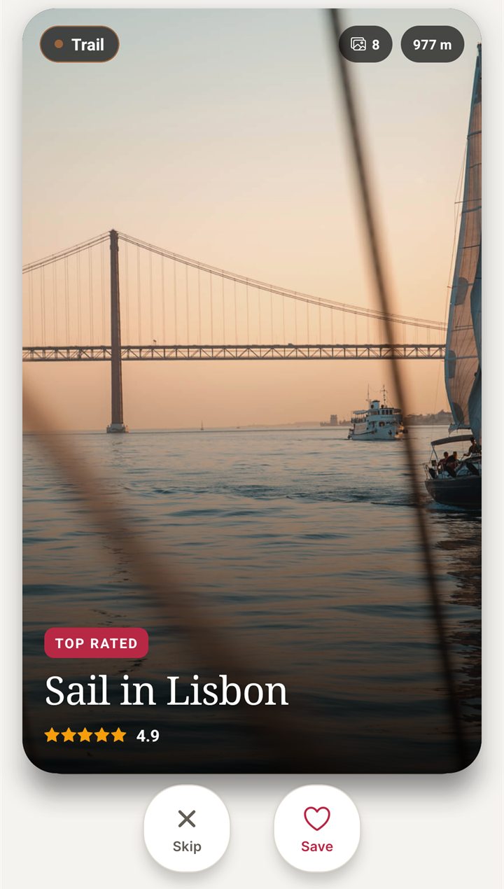
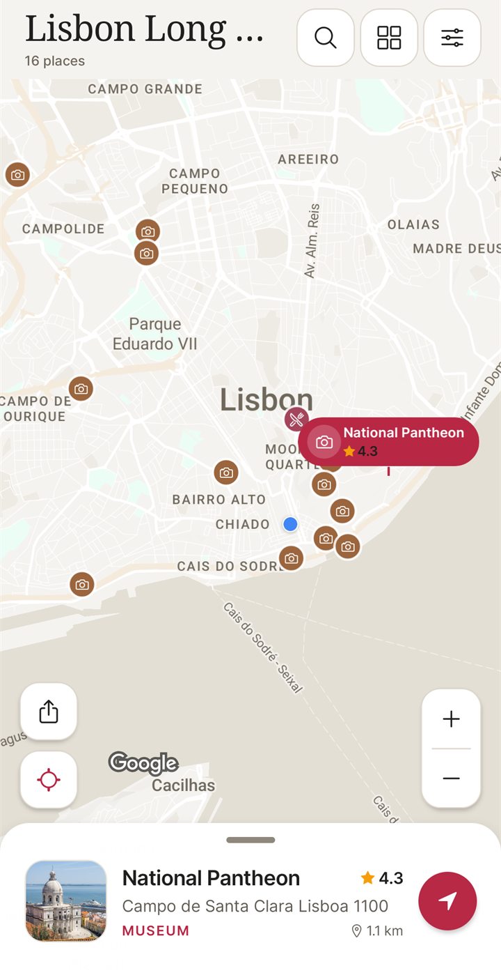
I built NomadSwipe, an Android app. You pick a city and it shows real places one card at a time, with the category, rating, distance and whether the place is open. You tap Save or swipe right to keep one and skip to pass. Kept places are pinned on a map for that trip, and the list view sorts by rating, distance or A to Z. You can also search for a destination and add custom pins.
How it works, as the app describes itself
- Swipe: choose a city and go through its places.
- Save: keep the ones you want.
- Map: see them pinned on the trip map.
- Go: open Directions, Website or Call from a place's card.
- Strength: you do not need a list first; the app puts real places in front of you and the map fills as you save.
- Limit: it does not import a My Maps file and has no layers or drawn routes. Use My Maps for that.
- Limit: it does not draft a day-by-day schedule; you decide the order of your days around the map.
- Limit: the base plan covers 3 trips, and Premium (Monthly or Lifetime) removes the base limits. It is Android only for now, and an iPhone version is coming soon.
Which to choose
- You want full control of every pin, layer and route, and you are at a computer: stay with Google My Maps.
- You want a ready day-by-day structure with the map beside it: Wanderlog or Stippl.
- You collect addresses from many places, including Google Maps: Mapstr.
- You want a record of the route as you travel: Polarsteps.
- You are driving and want stops along the way: Roadtrippers.
- You have a city but no list yet, and you are on Android: NomadSwipe.
For a wider list, see trip planner apps for Android, the steps to plan a trip on a map, and alternatives to Google Maps lists, which covers the saved lists inside Google Maps instead of My Maps.
Bottom line
Google My Maps remains the most flexible way to draw a trip yourself: up to 10 layers, 2,000 places per layer and 10,000 per map, sharing by link, and export to KML or CSV, all from Google's own help pages. It offers no day-by-day itinerary in the pages I read and describes building maps in a browser. Wanderlog and Stippl add the itinerary. Mapstr suits collecting addresses. Polarsteps records a trip as you go. Roadtrippers suits driving. NomadSwipe, which I built for Android, is for finding places by swiping when you have nothing to map yet.
FAQ
Is there a Google My Maps app?
Google's My Maps help pages describe building a map in a browser, and its Android help page says My Maps is not available for Android. Google's My Maps page says you can view custom maps in the Google Maps mobile app.
How many places can a Google My Maps map hold?
Google's help pages say a map can have up to 10,000 lines, shapes or places, a layer can have 2,000, and a map can have up to 10 layers. Maps are also limited to 50,000 total points in lines and shapes and 20,000 data table cells.
Which app is closest to Google My Maps for a trip?
It depends on what you use My Maps for. Mapstr is the closest for collecting saved addresses on a shared map, and its homepage says it imports addresses from Google Maps. Wanderlog and Stippl put an itinerary and a map in one app.
Can I take my My Maps data to another app?
You can export a whole map to KML or KMZ, or a single layer to CSV, according to Google's share and download page. I did not test whether any app on this page accepts those files, so try a small map first.
Does NomadSwipe replace Google My Maps?
No. I built NomadSwipe for finding places by swiping and keeping them on a trip map, not for drawing routes or importing a map. It is Android only today, with an iPhone version coming soon.
Nothing on your map yet? I built NomadSwipe for Android: swipe through real places in a city and keep the ones you like on a map.
Get NomadSwipe on Google PlaySee also: Google Maps lists alternatives · Save places for a trip · Swipe travel apps compared · NomadSwipe home · All comparisons